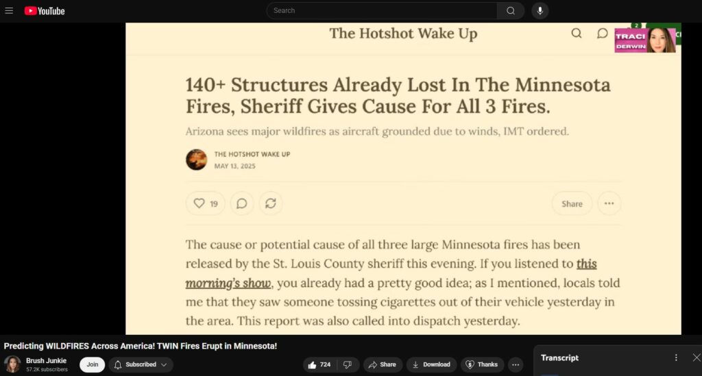
Predicting WILDFIRES Across America! TWIN Fires Erupt in Minnesota!
Zionic mass-media totally controlled
Wildfires are sweeping the nation, leaving destruction and chaos in their wake. From the west coast to the east, it seems like nowhere is safe from the flames. In this video, we take a look at the devastating impact of these wildfires, the heroic efforts of firefighters, and what you can do to stay safe. With footage of the fires and the destruction left behind, this is a must-see video for anyone concerned about the state of our nation. Don’t miss out on this in-depth look at the wildfires erupting across America!
Its getting crazier every week, month, etc. I’m not sure enough people know what we’re all dealing with. They are capable of so much destruction and death. What the system has done to me is horrible. Much worse exists, of course, but I feel myself breaking down physically and mentally. Thanks for trying to awaken the masses, but im thinking its way too late.
On the whole “we” barely know what we’re dealing with … until we begin to understand JOHN G TRUMP was behind early development of energy weaponry; until we begin to realize the Jesuit motto GO FORTH AND SET THE WORLD ON FIRE is literal; until we see ERIC777 youtube which shows DEW maker Raytheon controlled by Jesuits; until we realize America is largely a Protestant nation, sworn against by Catho Jesu of Vati in Rome. Until we understand WHO and WHAT the REAL enemy is, and HOW and WHY they are doing what they’ve always been doing, then we really understand extremely little, despite our arrogance.
The trees are absorbing the aluminum that’s being sprayed from the the chemtrail program how do you put a piece of aluminum inside of a microwave and see what happens you see that melted wheels and engine blocks well there you have it the tree is absorbing the aluminum and the soil along with the water that you mentioned and yes the electromagnetic energy that’s burning everything is also burning that tree from the inside out now let’s see if this gets erased from the comments
A video popped up in my feed today of Congress woman Harriet Hageman (WY) speaking in Congress about (edit:) the 2001 Roadless Area Conservation Rule that then-President Bill Clinton signed/enacted on his way out of office, a bill that his administration’s top wilderness (?) official (position, I forgot) admitted that although it would be disastrous for some states/regions, that fact was acceptable and worth it in order to have a blanket/one-size-fits-all national policy regarding forest management,. And here we are…
DEWISH is an ORGanization and WILDPHYRES is a COMpany both focused intensely on this topic
Just in time as the wildphyres are ramping up using energy weaponry developed in substantial part by his uncle JOHN G, here is TRUMP firing off large swaths of NOAA.
Another source for understanding increased electromagnetic increases is Stefan Burns, geophysicist podcast. DEWs take advantage of present conditions to direct and enhance geo events. We know this for a certainty by now.
“Fire season” is a psyop; the idea of a fire season is absurd! The woods will always burn if you set them on fire unless it’s raining of course.
Its not called the windy city because its actually it based on early chicago politicians who would fillerbuster for hours
Why is it you never explore the about the new developments on every location there’s a fire,, like I mentioned about microgrids,,”every fire there’s a project before hand,,here’s a copy on Minnesota fire!!! The St. Louis County Board meeting on May 13, 2025, focused on a significant development agreement with Eden Renewables to construct a solar energy facility on the closed Hibbing Landfill site. This project marks a pioneering step for St. Louis County, as it will be the first commercial-scale solar installation on a closed landfill in Minnesota and one of the largest in the nation. County Administrator Gray emphasized the importance of this initiative, highlighting its potential to generate renewable energy, create a new revenue stream, and utilize underused landfill space effectively. The proposed solar installation is expected to have a capacity of at least 10 megawatts, which could power approximately 1,800 homes in the area.
Wind is an electromagnetic phenomenon. If the energy weaponry is charged up too quickly, measurable magnetic anomalies occur, as was shown by Dr Wood in her book about Where Those Towers Went. Therefore, THEY have taken to ramping up slowly the energy weaponry (to reduce the telluric disturbances); however, the side-effect of that go-slowly trade-off is the high-winds for hours or days prior to the onslaught at the target event location.
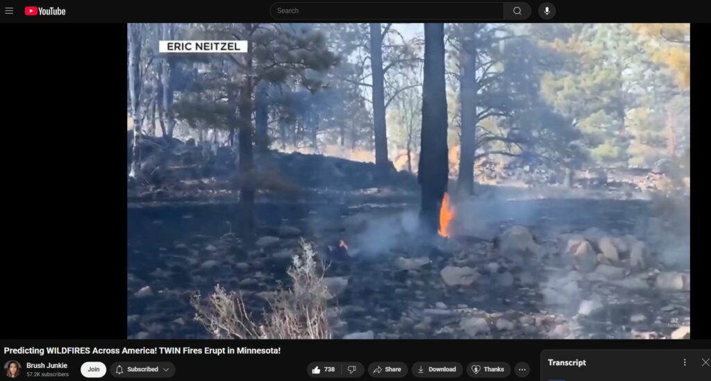
Over 100 wildphyres ignited over the weekend in MN alone. 4:15 in
And of course all the hallmarks of DEW conflagration…
Autoglass melts at 2,700 degF. Hottest, forest fire burns at 1480 degF, with the right type of wood under the right type of condittions. What we see here is en open-air fire with fuels that don’t burn that hot, and there’s not enough of that fuel to have melted the glass so completely.
Metallized micromist inside the windshield glass (to repel infrared heat rays) is actually weaponized to superheat the glass by the microwaves of the NRGWeppornery.
Homes cremated down to white ash. Wilted, warped, distorted metal.
White ash footprint, almost no black soot from carbon powered flame. All nearby trees not burned.
Dried out a dessicated but not necessarily combusted.
16:45 Sheriff Gordon Ramsey telling how the structures were burned down completely to ash: “everything was gone”. You couldn’t even tell that there had been a structure there. Zero partial burns. 100% complete dustifications.
80 mph hurricane force winds. Mentioned 18:00 in. AZ Greer Fire.
Similar reports of ferocious, non-extinguishable, self-restarting phyres — “Twice the fire seemed thwarted, only to have it come back ten-fold.” 20:00 in
Bryce Fire followed the Hela River! — THE ENTIRE LENGTH OF THE HELA RIVER HAS BURNED AT SOME POINT WITHIN THE PAST FIVE YEARS
Low-lying areas, wetter, tend to be more often and more intensely burned.
Trees burn at bottom and from inside-out. “When trees burn from inside-out, something else other than normal combustion is taking place.” 24:30 — Regarding “it seems as if the moisture/water is attracting the flame” — microwaves superheat water. DEW weaponizes metals (which also superheat, think of a fork in a microwave oven) and also water. The metals and water BECOME THE FUEL.
Lawrence Livermore Lab has a LINAC high voltage ion-gun. So too does Brookhaven National Labs. Brookhaven ion-gun is headquartered in building #911 and it is direct line of sight 61.1 miles to WTC at an angle of 119 degrees. No, you couldn’t make this stuff up. Go on google maps and verify for yourself the gematrial encoding in this wholly manufactured 911 event, only a Total CoinciDUNCE to the magnificently stooged or totally controlled anti-Americana.
Lake Manitoba, only structures are burning! “It doesn’t look like the fire started on one side and then went to the other side, but rather it appears that the whole [structure] started on fire at the same time.” 29:30 in
~”Historically, when you would lose structures in a [real] forest fire it was because the burning forest caught your house on fire, not [like modern wildphyres in which] a few inches of grass ignited your whole house all at once.” 30:00 in

Transcript
Click to expand
0:02
hello everyone i'm Tracy Derwin and I'm here with Shane Buell in today's video
0:07
we're going to be providing some fire forecast in the Chicago and Arizona area
0:13
and then also go over the current fire or fires in Minnesota Nebraska and
0:20
Arizona and there's also one in Canada in the Ontario area so uh before we get
0:27
started if you haven't subscribed yet please do so before you leave and like comment and share this video especially
0:34
if you know people in these areas that we're going to be talking about because these red flag warnings and um fire
0:42
warnings have become extremely accurate so um you know if you are in these areas
0:48
you probably want to get prepared for what's to come all right so we'll start out with what
0:56
we have so far with the Chicago Fire Weather Watch and this
1:03
started these start today the 16th and possibly by the time you see this video
1:11
we might have already seen uh fires break out in this area
1:17
so they're saying high winds and they're telling everyone not to start any fires
1:23
is that right yeah high winds and low relative humidity it's mainly the low relative humidity that's uh triggering
1:29
this because Chicago typically does have uh steady winds right it is a windy city
1:36
so right it's kind of unusual that they're doing wind warnings in Chicago i
1:42
thought found that interesting well it's not necessarily just a wind warning uh so usually when you have fire weather or
1:48
red flags it's because of wind combined with low humidity and Chicago is normally a humid area i've been there
1:54
several times it's got a large lake right next to it and so having low relative humidities in the Chicago area
2:01
is kind of a rare situation right and we have seen very similar circumstances in
2:08
LA uh Hawaii um Texas so it seems to be
2:14
kind of a trend you know they give you these wind low relativity low humidity warnings and tell people not to you know
2:22
start any fires although we do see they have prescribed burns regardless of
2:28
those warnings okay do you want me to u move on to
2:34
the Minnesota situation or you want to go into a little bit more of the No we
2:39
can go ahead and move on to this um so yeah Minnesota also had red flags prior
2:45
to the fires breaking out which is why we give the warnings for uh Chicago right now because Chicago has high winds
2:52
and low humidities and uh that's what Minnesota had as well um there were 77
2:58
counties in Minnesota that had red flag warnings before these recent fires broke out and uh they did enact a burn ban and
3:06
one of the things that had been I guess leading up to this was the uh campfire
3:11
thing so uh here go back here and you can see they mentioned campfires here and they did also mention that the red
3:17
flag warning started from 11:00 a.m to 10 p.m on Sunday well the fires in Minnesota broke out exactly a half hour
3:24
after the red flag warning started and so yes now this one actually this is an
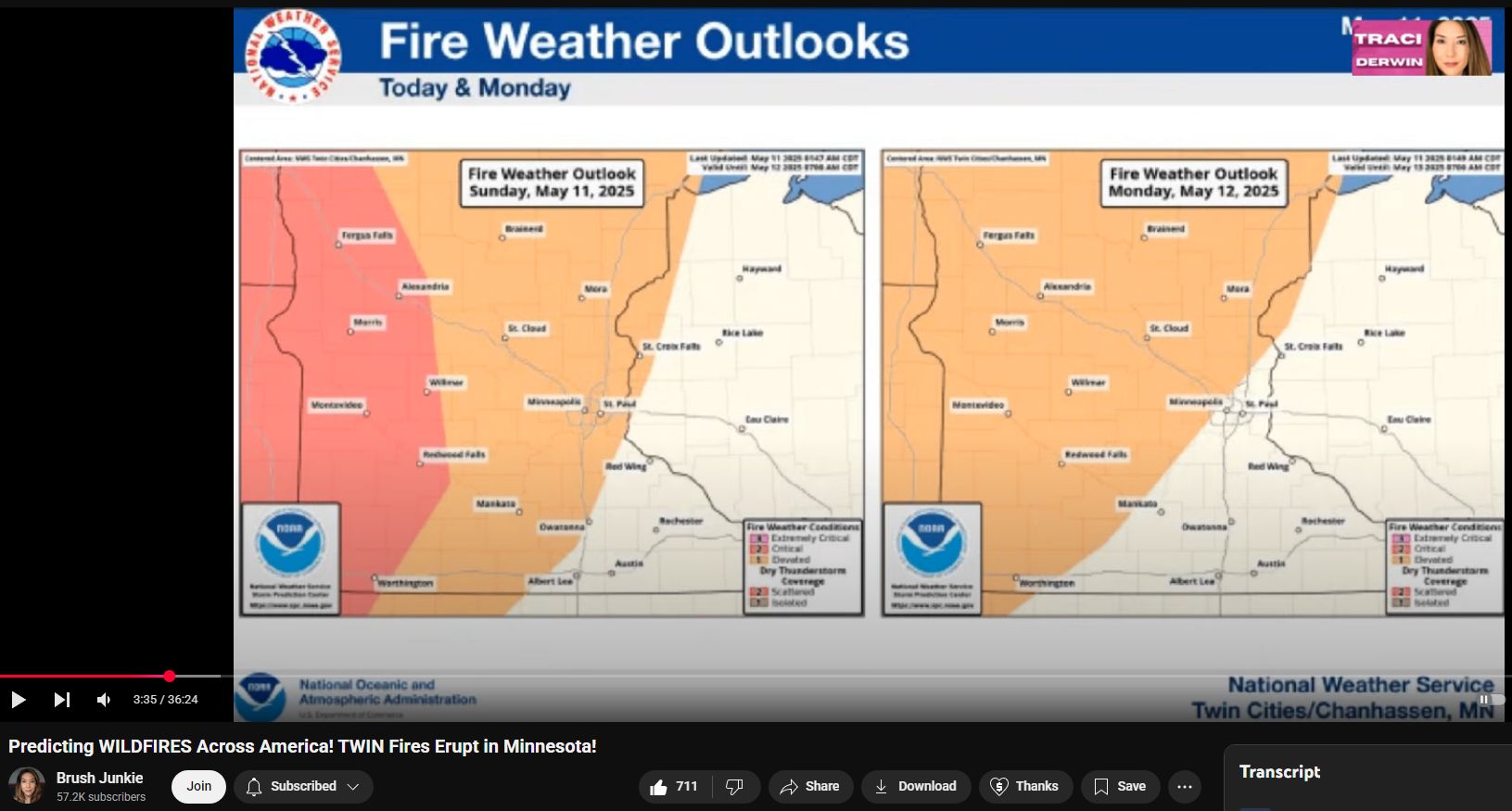
3:30
update from Noah and the National Weather Service on the fire weather outlooks for Sunday May 12th which is
3:36
the day that the fires broke out in Minnesota however uh this this was
3:42
actually released about 8 hours before the fire started so this was released about 3:30 a.m and the fire broke out
3:47
about 8 hours later at 11:30 a.m and as it turns out the Noah weather fire
3:54
weather maps were scary accurate because uh this is like the exact places where
3:59
the fires have broken out so you can see that the uh the elevated and critical uh
4:04
fire weather warning areas go all the way from Nebraska up to northern Minnesota and it just so happens that
4:11
that's exactly where these fires broke out so um we did have some fires in Nebraska which I will cover uh after we
4:18
go through Minnesota and and Arizona too but uh there were over a hundred fires that broke out over the weekend in just
4:26
Minnesota alone um I believe there were also like 40 fires in Wisconsin but they
4:31
were much smaller fires and they've been under control and then I see there those little green um marks those are
4:38
prescribed burns right and they're many yes yes so everywhere you see a little green RX that's actually a prescribed
4:45
burn however it's taking place during a red flag warning which means there are high winds and any fire can get out of
4:53
control during high winds even a prescribed burn as we've seen in the past and we will show again in this video as well right all right so then I
5:01
have a satellite view here that shows northern Minnesota um as well as some of Manitoba and Ontario so at the bottom of
5:09
this picture you can see the fires that broke out in northern Minnesota but you can also see that there's fires in in
5:17
Manitoba and Ontario uh as well these are east of Winnipeg and I will show a
5:22
video from one of those later all right so now as far as Minnesota goes we have two fires that started right next to
5:28
each other and they are actually starting to grow together the evacuation zones have started to overlap and this
5:35
fire these two fires have been now combined into one fire called the Brimson Complex fire uh these two fires
5:42
started relatively simultaneously and very close together and so they were
5:47
kind of nicknamed the twin fires at first but now that they're merging this into one fire is called the Brimson comp
5:53
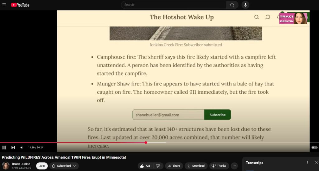
complex fire so that uh is so the Brimson Complex fire is made of the Camp
6:00
House fire which began on May 11th at about 1:30 p.m and it is now 15,000
6:07
acres approximately with still 0% containment the other fire that was part
6:12
of this complex is the Jenkins Creek fire which started on May 12th at 11:19
6:18
a.m and is now 20 and a half thousand acres also with 0% containment uh there
6:25
was also a third fire nearby called the Munger Shaw fire this one is now at
6:31
1,700 plus acres also at zero um let's see
6:36
here the Camp House Creek or the Camp House fire was allegedly started by a
6:42
campfire that was left unattended we've heard that story over and over again and we also heard that in the article uh
6:49
about the red flag warnings and the campfire burn ban but there was also
6:54
references to campfires in the red flag warnings leading up to this fire and I
6:59
have a video that I want to play that kind of highlights that the Minnesota Department of Natural Resources DNR is
7:06
also halting the issuance of open burning permits and strongly discouraging campfires but that's not
7:12
all on Sunday a fire weather watch will be in effect for 61 counties across the
7:17
state due to near critical fire weather conditions always ensure that any fire
7:23
whether from burning vegetation or a cozy campfire is completely out before leaving the site asterisk if it's too
7:30
hot to touch it's too hot to leave let's all do our part to keep Minnesota safe this weekend
7:38
all right here let me remove this image here so going into the Minnesota fires there was a red flag warning and they
7:45
were talking about be careful with your fires you know make sure not to leave a campfire unattended and make sure it's
7:51
put out all the way if it's uh too hot to touch it's too hot to leave well then the very next thing that happens is a
7:57
campfire is allegedly left unattended and it starts a wildfire and then not
8:03
only that but they name it the camp house fire so if you ask me it almost
8:08
seems like there was a little bit of a uh I guess a propaganda campaign ahead
8:15
of time to put this thought out into the mind of the public of campfires being
8:20
dangerous and that is what exact actually allegedly started in the very next fire so I just wanted to highlight
8:26
some of that it's interesting cuz uh Paradise they call it the campfire but now they're making it the camp house
8:33
fire kind of indicating that these are also residential fires oh right
8:38
combining the whole campfire with house kind of like getting us used to this
8:44
idea that the houses are on fire right yeah i had uh had not thought of that
8:52
actually all right so let's see here i have another video also uh from
8:57
Minnesota and this is from the Department of Natural Resources and the Forest Service of Minnesota you see some
9:03
of the aircraft there they've had aircraft both planes and helicopters that were pre-staged by the DNR and the
9:10
US Forest Service around that area including some at the Ele airport yesterday they posted a picture of one
9:16
yesterday morning at the Ele airport ready to go oh and then of course a couple hours later the fires burst out
9:23
so yeah the DNR and the Forest Service they pre-staged firefighting equipment at the airport just hours before the
9:30
fire actually broke out so that was either really good planning on their part or something
9:36
else all right and then I do have uh one little clip here I want to show of these fires now this is the Camp House Creek
9:42
or the Camp House fire and the Jenkins Creek fire and then you also see the Munger Shaw fire there as well but you
9:48
can see just how close together these fires are and how approximately they started uh in in time to each other okay
9:57
so then now I want to go to some of the damage indicators that we have so I've
10:04
been you know I heard that there was homes and vehicles that were impacted in Minnesota but it took about a day or two for that footage to come out but I
10:11
finally have found it and here we have a car in northern Minnesota this is from
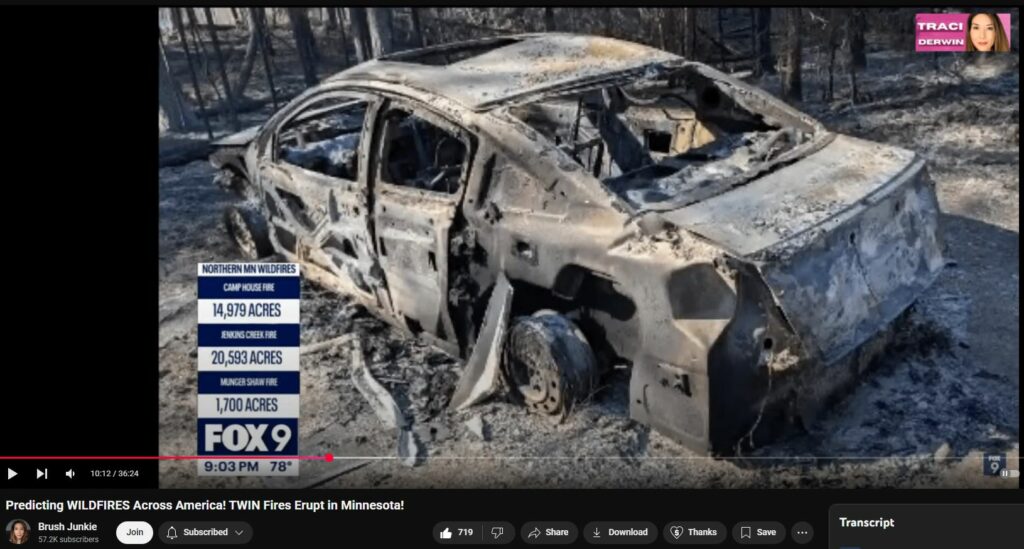
10:16
the camp house fire and the reason that I saved this photo is because you can see that there is melted glass uh
10:23
there's a little bit there on the back windshield uh but then if you look where the steering wheel was on the front dash
10:30
you can see a large piece a large layer of melted glass that's draped across what was left of the dashboard there so
10:37
uh glass auto glass melts around 2700° F
10:42
however forest fires the hottest of which only burn at you know a maximum of like 1479 Fahrenheit and that's with the
10:50
right type of wood under the right type of conditions so let's say you were to build a rocket stove with the right type
10:55
of pine in it you might be able to get autoglass to melt under those conditions however what we see here is an open air
11:01
fire uh with fuels that don't burn that hot and there's not enough of those fuels either to have melted the glass so
11:08
completely all right we also have homes that were pretty much completely
11:13
destroyed into like white ash and very small debris with the exception of like
11:19
steel and stone so what we see here is only a chimney left behind because it's made of brick or a type of stone and all
11:27
the other materials are basically just rubble or ash we also have another house here this
11:33
was a finished style homestead and the reason I included this image is to show the the warped and melted metal in the
11:40
back of the house there um another thing I wanted to point out is the completely unburned trees in the background and the
11:47
grass in the front is only scorched in a small patch so and I have seen in other
11:52
videos and and footage that this was mostly a grass fire uh some of the trees did catch and crown but it wasn't mostly
11:59
a crown fire it was mostly a grass fire okay we have another house here that was
12:04
reduced to like white ash and rubble and we see in the background trees that are intact now I did reach out to forensic
12:11
arborist Robert Br and he says that these are likely silver birch trees they could be aspen but they're most likely
12:16
silver birch and they're interspersed with various conifers from the pine family uh both of those species are high
12:23
water loving trees very flammable and so if the house here burned those trees should have also burned and it's an
12:29
anomaly that they did not all right and then another structure
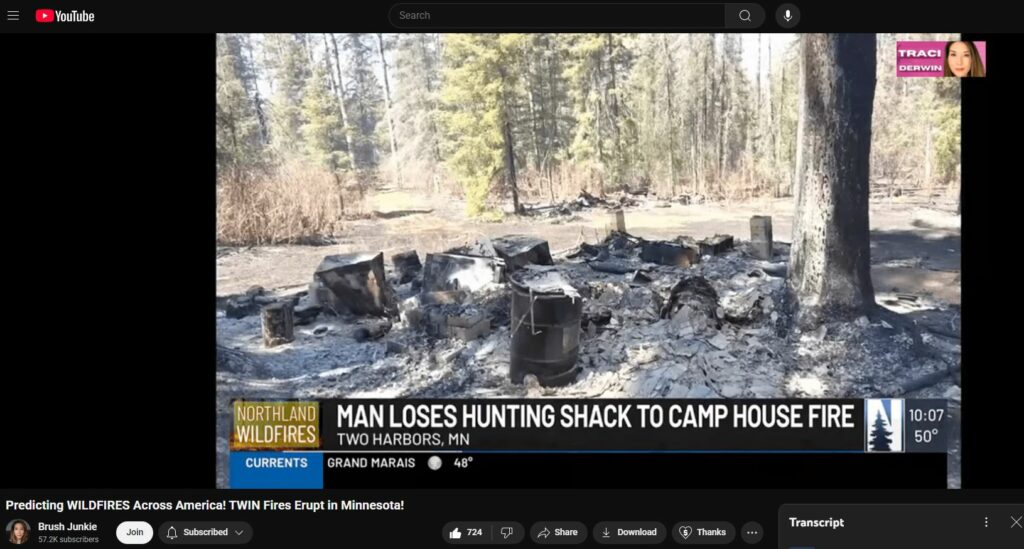
12:34
that was destroyed in the camp house fire was a hunting shack this is the before photo and this is one of the
12:42
after photos what stuck out to me in this image was immediately the white ash
12:48
footprint there's very little black almost no carbon soot which you would see from a normal combustive flame and
12:54
then when you look back at the trees the trees are actually still intact the grass is only scorched in patches not
13:01
even all of the grass is burned but when you look at the bushes at the edge of the tree line there the bushes are
13:06
actually not burned but they look very dried out uh they look desiccated as if they were put in a microwave or
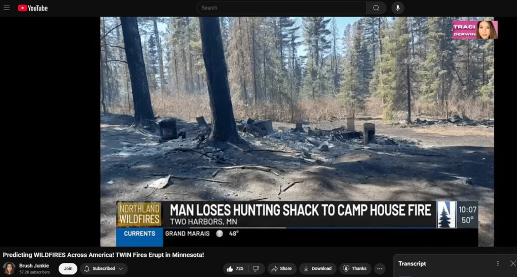
13:14
something all right and then this is just another image of that shack that shows the forest behind here uh how
13:20
intact it is but you can see that there is some browning as if it was dried out and desiccated but not actually
13:26
combusted so it looks like this was a victim these trees were a victim of radiant heat but not necessarily
13:32
combustive flame okay so all in all in miss or not
13:38
Michigan there have been at least 140 structures that were already lost and they also in this article give what they
13:45
believe the causes for these fires to be um so for example the Jenkins Creek fire
13:51
is alleged to have started from a discarded cigarette on the highway now
13:57
uh there was this is based on a text message that was received by a woman who says "These photos are from right now
14:03
but my husband drove by yesterday when it had just started in the ditch." And he definitely said it looked like a
14:09
cigarette started it now if anything this is what I would call anecdotal evidence it's not photographic it's not
14:16
video we have no sort of forensic proof of this other than some guy's word so I
14:21
would say that's not very strong you know evidence there all right and then the Camp House Creek fire the sheriff
14:28
says this fire likely started with a campfire that was left unattended a person has been identified by the
14:34
authorities as having started the campfire and now the one that's really strange to me is the Munger Shaw fire
14:41
which was the smaller fire uh the third fire that was to the south uh that fire appears to have started with a bail of
14:47
hay that caught on fire the homeowner called 911 immediately but the fire took off now I had seen a separate report on
14:55
this where the fire or the farmer actually claims that he was present at the time and the bail of hay actually
15:02
caught fire on its own which to me almost sounds a little bit like spontaneous combustion because there was
15:08
no embers there was nothing else you know he was present and there was no other humans around that could have
15:14
caused that fire so what sparked the hay um I have heard theories about like moldy hay or wet hay generating heat
15:21
inside of it although I've never heard of hay actually generating enough of its own heat to ignite itself so to me that
15:28
seems very strange all right you know when I saw that picture of the three fires it kind of reminded me of the LA
15:35
fires where there were three kind of main fires that started around the same
15:40
time oh yes just unusual that so many would start at the same time right yeah last
15:48
fall there was a video that had circulated of the bridge line and airport fires uh that you know in the LA
15:54
area that had all started relatively simultaneously um and yeah from
16:00
satellite it looked like they started at the same time basically all right let's see i think I have one
16:05
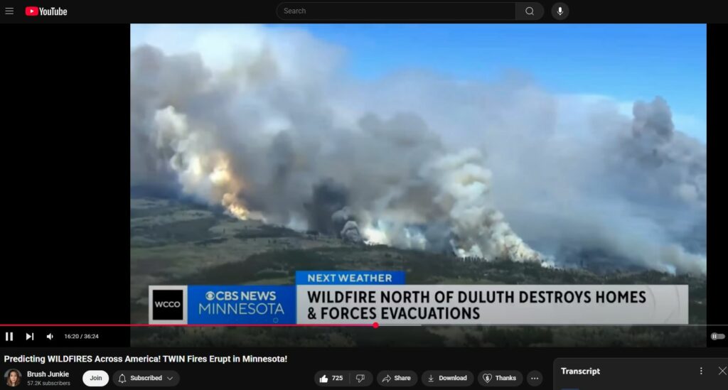
more video I want to show from Minnesota before we move on and this is you can see the camp house fire has burned
16:11
several buildings and has charred some cars as well the fire began yesterday and has burned more than,50 acres which
16:19
is about two square miles crews had to evacuate dozens of homes and businesses a highway in that area is shut down as
16:26
well while firefighters try to stop those flames from spreading we know that there have been three cabins and a
16:31
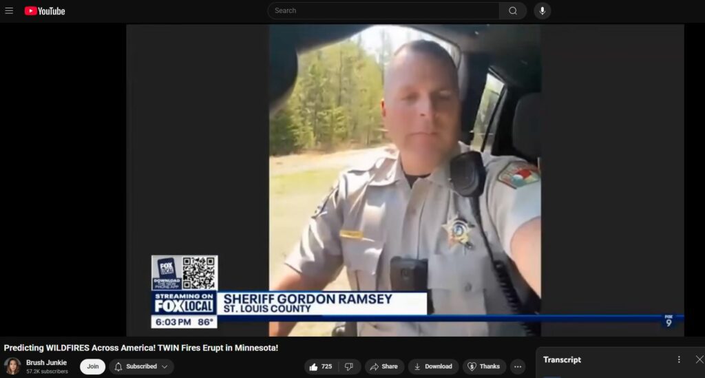
garage that have burned but that's only what they know of so far because the sheriff said there's a lot of areas they can't get into yet he spoke to Amy
16:39
Hawkard on Fox 9 all day this afternoon on the Fox Local streaming app and here's what he said about what he saw so
16:45
far drove around and looked at some of the structures that were lost yesterday and really other than standing chimneys
16:51
and you know some of the cement work uh and some burned out cars you never would have guessed there was even structures
16:56
there they just everything was gone yeah so according to Sheriff Gordon
17:03
Ramsay not Chef Gordon Ramsay um everything had basically completely been burned like completely destroyed it was
17:09
gone you couldn't even tell there was a structure there to me that doesn't sound like a natural wildfire which would
17:14
leave behind some boards and uh you know some carbon yeah yeah it wouldn't just
17:20
be a white pile of white ash there would at least be some rubble and some structure left
17:28
all right and so I think that's everything I have on the Minnesota fire and so now I want to go into the Arizona
17:36
fire as well so we do have some uh fires uh in the southwest and they also
17:43
started with red flag warnings as well so there were red flag warnings for eastern Arizona and western New Mexico
17:50
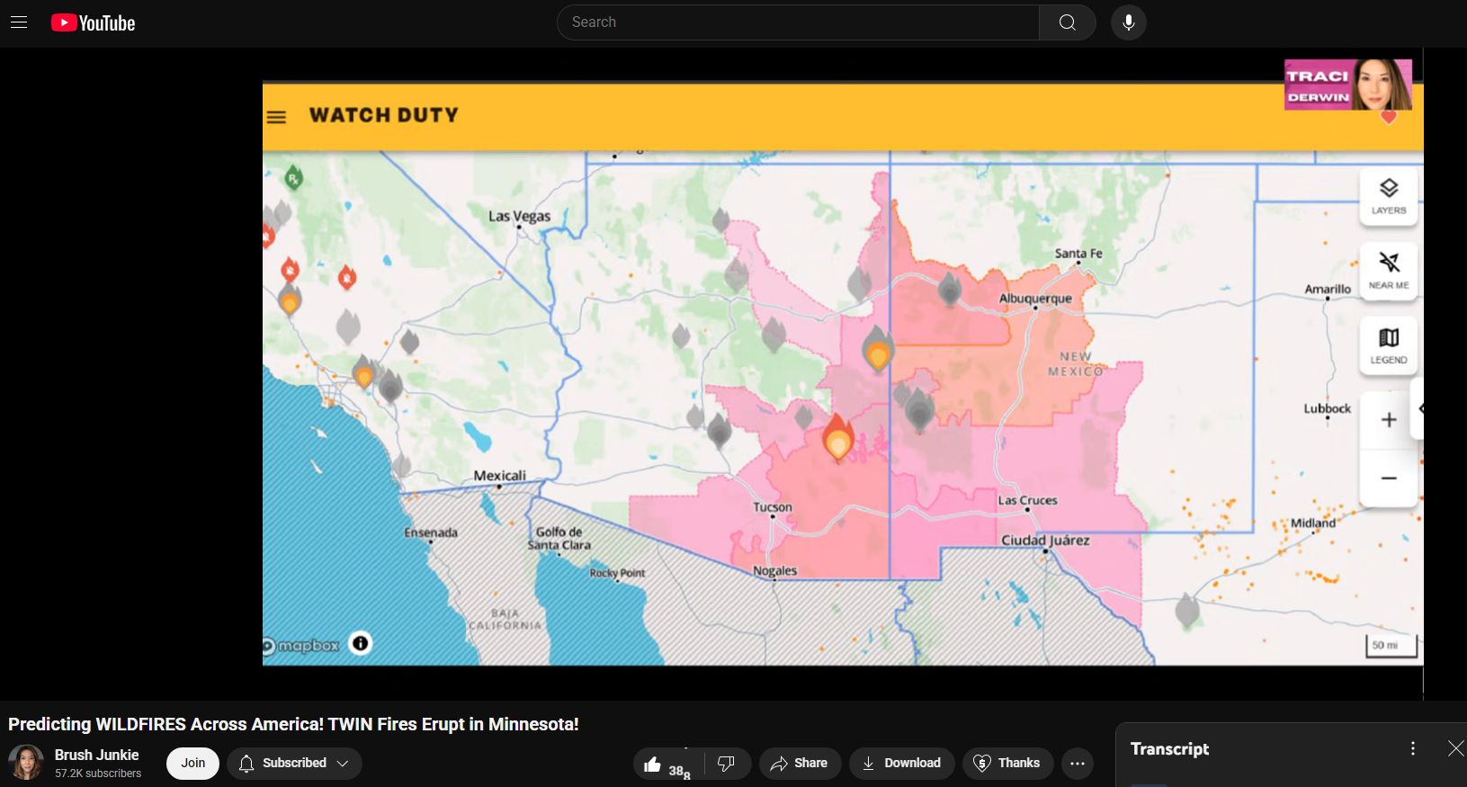
however we've basically only seen fires erupt in Arizona at this point um one
17:56
thing I wanted to point out and this is from the previous article however they also mentioned Arizona they said Arizona
18:02
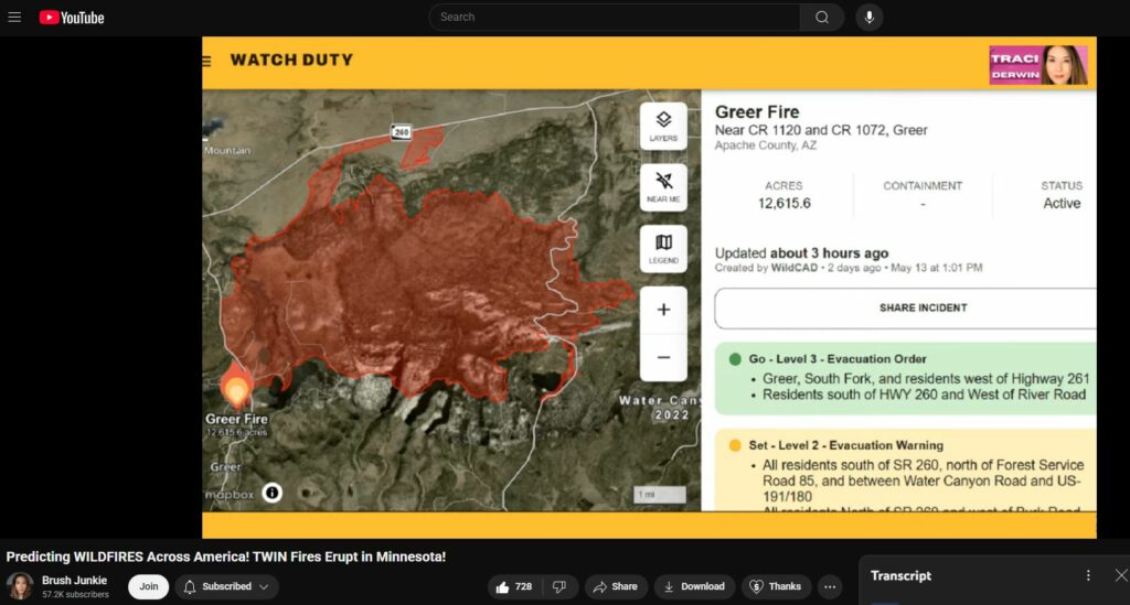
popped multiple fires that are being fueled by winds exceeding gusts of 75 miles an hour um and the Greer fire had
18:09
at that point already burned over 3,700 acres although now it is at over
18:16
12,600 acres so these winds in Arizona have been really crazy you know you're
18:22
talking 75 plus mile per hour wind and that is just going to it's going to spread the fire even faster than a mile
18:28
a minute in some cases that reminds me of Lahina they said there were 80 mph
18:34
winds so craft couldn't be in the air right very very similar
18:41
yeah helicopters also had difficulty dropping water on this fire uh they eventually were able to get the super
18:47
scooper airplanes out and you know to drop with fixed wing aircraft but the wind was definitely an issue not just
18:53
for the spread of the fire but for the fighting of the fire as well that is also Do they have prescribed burns do
19:00
you know if we had prescribed burns in Arizona too uh well let me see i can check the map
19:05
here it doesn't appear that there were any prescribed burns in Arizona at the time which is which is a good thing it
19:11
seems like the at least the Arizona firefighters had the sense not to start things on fire during a red flag warning
19:17
right yeah um so yeah the Greer fire is at 12,600 acres it was allegedly wind
19:24
driven which is just like we saw on Maui but also just like we saw on Maui this
19:29
fire was allegedly started by a damaged power transformer so they're alleging
19:34
that the wind had damaged a power transformer which sparked and started this
19:40
fire all right uh let's see here there may actually be structures that were
19:46
impacted here um let's see here i'm going to play a video uh from this
19:53
Arizona fire the human cause fire began May 7th just before 3:30 p.m along the
19:59
Hila River about 3 miles west of Puma twice the fire seemed thwarted only to come back 10fold the Puma Fire
20:06
Department was first on scene and appeared to have it knocked down however high winds and dry fuels soon helped it
20:12
grow to 50 acres by 7 p.m wednesday wildland firefighters battled it through the night and had it at 80% containment
20:19
when it was still only 160 acres however high winds Friday morning helped the fire jump 25 to 30 foot containment
20:26
lines putting residences along Bryce Eden Road and eventually those in Fort Thomas along the river corridor in the
20:32
set notice for evacuation as the winds swept the fire northwest toward Fort Thomas the fire crossed Bryce Eden Road
20:40
and the bridge remains closed okay so that was actually a different fire at Arizona um I guess
20:47
that was everything I had covered i had already covered everything from the Greer fire um I just wanted to say that
20:52
there are structures that will be impacted in this Greer fire but we have no images of them yet but they will be
20:57
coming out soon it looked like they were going underground to a structure underground in that video yes there was
21:05
a bridge that was also damaged uh so the video I just showed was actually from the next fire that I'm going to cover
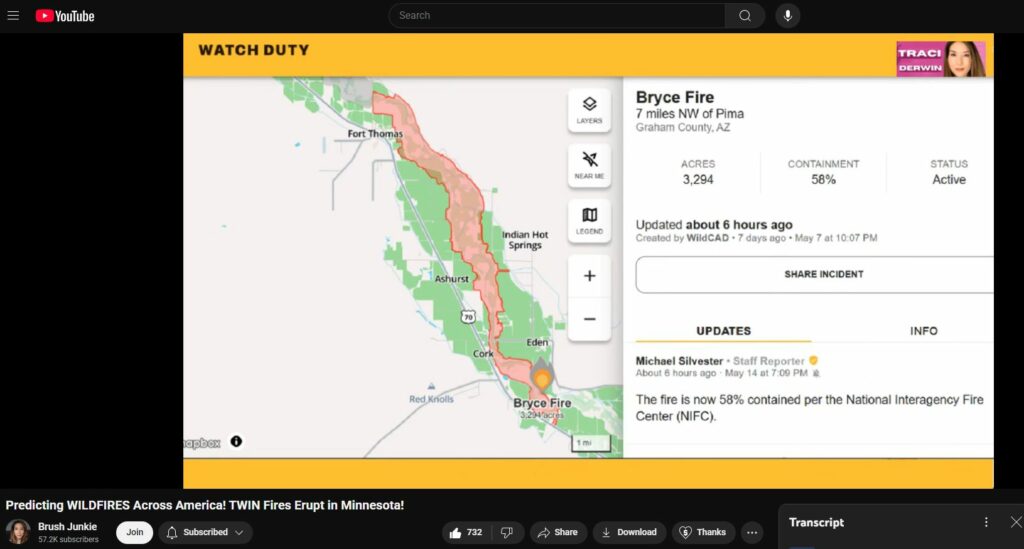
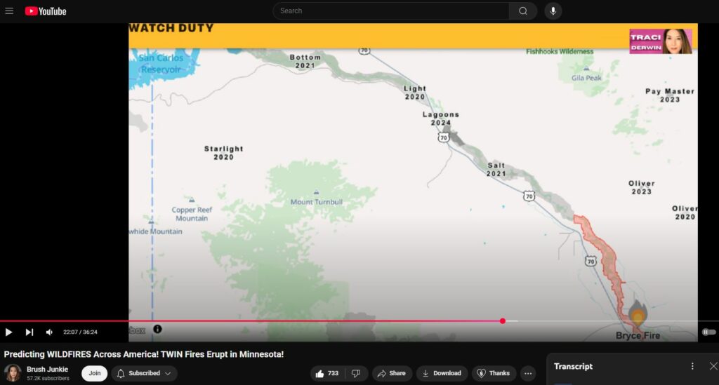
21:11
which is called the the Bryce fire uh uh let's see here uh the Bryce fire uh
21:18
started in the Hila River basin and it spread along the river actually of all
21:24
things and uh this fire was allegedly human-caused um I haven't actually found
21:29
the story on that so I really don't know the backstory on how this was human-caused but one thing that did
21:35
stick out to me was not only the long skinny burn scar but the fact that it
21:40
followed the river itself so this actual fire had followed the Hila River and so
21:46
I actually zoomed out and I enabled historical fire burn scars and I could see that all the way from Fort Thomas to
21:53
the St san Carlos reservoir the entire length of the Hilo River has burned at
21:58
some point in just the last 5 years so you know within the last 5 years this
22:04
entire river has had its river banks burned and I thought that was really strange and I know Tracy has also
22:11
noticed that you know lowlying areas tend to be affected more right we saw
22:16
that in Malibu the the canyons were burned and then in LA or in Maui the
22:23
earlier fire in Kula started in a gulch they said it started on the bottom of that and then worked its way up
22:31
so that is something we're seeing often right yeah river beds really strange
22:38
phenomenon and yeah and I'm not sure whether it's following the water itself
22:43
or whether it's actually maybe coming out of the ground you know what I mean why it's affecting those lowlying areas
22:49
or maybe in an area like Arizona where it's deserty the river is where there is
22:55
combustible material versus I don't know just an idea that I had yeah that makes
23:01
a lot of sense actually okay so then we also have other fires in Arizona that have broken out um
23:08
that was the Bryce fire i don't think we have any structures that were damaged there uh but we do have another fire in
23:14
Arizona that has taken off as well uh we have one called the Blind Fire which is
23:19
about 5 miles southwest of HappyJack in Conino County Arizona this one is now
23:26
over 5,000 acres and it's only 14% contained now uh something suspicious
23:32
about this fire is that uh they you know this fire was reported uh days ago
23:38
actually it's been going since May 4th but they had put out a statement i think it was on May 11th or something i don't
23:44
have it handy here but I'm pretty sure it was May 11th the fire was at about 1,000 acres and they put out a statement
23:49
that the there was actually no personnel yet on the fire but they were going to I think May 12th or May 13th uh actually
23:57
start putting personnel on that fire um the day that they put out the statement the fire was only about a thousand acres
24:03
but the firefighters didn't actually show up until the fire was already at 5,000 acres so what were they doing
24:10
where was the fire department in this fire okay so um that basically is
24:16
everything I had for Arizona I believe uh no actually it's not i do have one
24:22
damage indicator I want to show and that's on a video here and uh what we
24:27
see here is a tree that's burning not only at the bottom but from the inside this is a pattern we've seen over and
24:32
over again from Maui to paradise and so many other places in between trees don't
24:38
burn from the inside out they're supposed to burn from the outside in when they burn from the inside out
24:44
something else besides normal combustion is taking place and that's where the moisture is so it seems like the
24:50
moisture is attracting the flame yes it seems as if the moisture or water itself
24:56
is conducting this uh electricity or perhaps being affected uh rotationally
25:04
by you know electromagnetic radiation so you know water as a molecule is not only electrically conductive but it's also
25:10
electrically polar has a positive side and a negative side and electromagnetic radiation will cause them to flip or
25:17
rotate which produces friction heating all right so that was everything
25:24
I think I have for Arizona and let's see here uh now I want to go into updates on
25:30
the other fires uh some of which we've actually reported on before um including
25:36
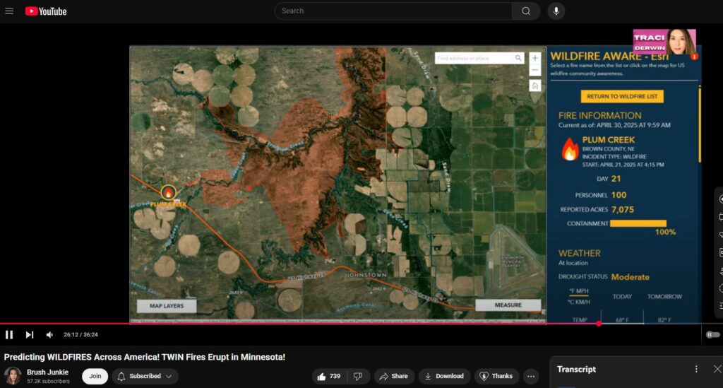
the fire in Nebraska so the Plum Creek fire it shows here is only 7,000 acres
25:44
but I have seen other reports that claim that it's 24,000 acres um I'm not sure if this fire was actually downgraded or
25:51
if this particular fire map just hadn't updated yet but I have been checking it and it has not actually finished its
25:57
update i just noticed this map it looks like it's a lot of farmland they look like plots of farms
26:04
or Yes it is a lot of farmland and what you see there those circles I believe
26:10
are like irrigation channels of some sort oh okay yeah and uh those
26:15
irrigation uh structures were actually part of a recent controversy involving Louzando trying to pass off a photo of
26:22
one of them as a UFO oh yeah that was okay yeah yeah yeah that's what those
26:27
structures are those are irrigation those are irrigation he said it was a UFO a shadow of a UFO right yeah yeah
26:34
those are not UFOs those are just for irrigation okay so uh I did want to point out that
26:40
the Plum Creek fire in North Central Nebraska began Monday when a prescribed burn coordinated by NE Nebraska Game and
26:47
Parks escaped its containment and it says here that the fire has now burned 24,000 acres between Ainsworth and
26:54
Valentine and I have found several sources that do quote this 24,000 acre
27:00
figure so um it could actually be accurate um now I did not find any
27:05
structures that were damaged in this Nebraska fire however they do claim that one at least one structure was lost they
27:12
say one non-primary residence which is like perhaps a second home of sorts and
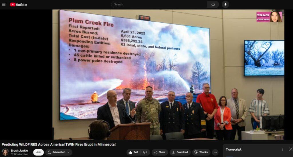
27:18
45 cattle were killed or euthanized in addition to eight power poles being destroyed now what's really strange
27:24
about this Plum Creek fire is that it was started by the fire department now how much more dystopian or Ray Bradberry
27:31
does it get you know I read Fahrenheit 451 and uh I know that there are dystopian futures that involve
27:37
firefighters starting fires uh I want to show a clip of uh this fire from Nebraska so this is the firefighter this
27:44
is the fire department after the fire became uncontrolled but these are this is the same fire and the same fire
27:50
department that started a controlled burn and then lost control of it you can see from the video just how violent the
27:56
winds are why on earth would they start a controlled burn in wind conditions like that thinking that they could keep
28:03
control over it not a smart move guys and we've seen that before
28:09
right the control starting during the red flag warning yeah during the red flag warnings that did happen in Florida
28:15
at the Okchobee Lake fire and that also happened uh last June on June 1st in
28:22
Tracy California during the Corral fire that was actually started by the fire department during a controlled burn and
28:28
then they walked away from it and let it get out of control and we have footage of them starting it right i believe
28:35
the Tracy fire oh oh yes yeah oh yeah they did it right out in the open in front of everyone
28:42
basically yeah but yeah that one actually that one also started on the property of Lawrence Livermore National
28:48
Laboratories so yeah that particular fire had a lot of suspicion around it because they started a controlled burn
28:54
next to one of those national laboratories that does tend to have fires just like we saw with Brook Haven in Long Island so and we saw in Colorado
29:02
Springs as well Space Force Base they had a fire too so yeah this is uh it's a
29:08
it's a kind of a pattern that we're starting to see where you have these national laboratories and Space Force
29:13
bases that have fires that break out on their properties all right uh let's see here
29:20
so the only fire uh the only other fire I have here to report on is one that's
29:26
burning in Ontario Canada uh so there's actually two fires uh but they're on the border of Manitoba and Ontario just east
29:33
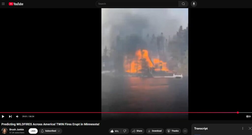
of Winnipeg and I'm going to show a clip of it here so what you see is this is a lake uh this is on the edge of a lake
29:40
and that house right there is burning so completely but the trees around it are not even touched so the trees are
29:45
completely intact and it looks like only structures are burning and so I slowed it down here so you can see not only is
29:50
this structure burning but burning so evenly along all the edges of the boards it doesn't look like the fire started on
29:56
one side and went to the other it looks like the whole thing started on fire at the same time and historically it's the
30:02
um trees and the brush that burn before the structures is typically what they
30:08
used to do yeah when you Yeah historically when you would lose structures in a forest fire it would be because the forest caught them on fire
30:16
you know not because a little tiny few inches of grass caught your entire house on fire that's not the opposite right
30:23
the structure is actually spreading to the trees right yeah
30:29
all right do you have any other ones i think I've covered everything that I had for today except for I just want to
30:34
touch uh some of the older fires that we have also covered so real quick there was the B-rock Creek fire in North
30:41
Carolina which three teenagers I believe were arrested over leaving a campfire unattended however this one is now
30:48
finally 100% contained after 27 days and then we also have other fires actually
30:55
so this is a 23-day old fire in West Virginia that has 10 personnel fighting
31:01
it but it's still at 0% so what are these guys doing twiddling their thumbs
31:06
uh if you thought that was bad we have a in Virginia we have a 46 day old fire
31:12
which is only 40% contained with 80 people fighting it you know uh you know
31:17
the these firefighters are not doing a very good job or they need a lot more help in my opinion um also in New Jersey
31:24
the Jones Road fire is now 75% contained at over 3 weeks in i took this a couple
31:32
days ago yeah this fire is still going and uh it hasn't grown in size but uh
31:38
it's still not 100% contained right i'll link the video we did on this one it's
31:44
very interesting how it's it's hitting the Pine Barons and the All right we'll
31:49
put it We can put a link up here yeah okay we'll put a a link we'll put it at the end screen and in the description
31:55
but the New Jersey one is is very unusual because of where it is and um
32:02
yeah we go into more detail there uh okay did we have any other fire reports
32:10
that's all the updates I have for today however there are going to be more damage indicators that come out of
32:15
Minnesota and Arizona i guarantee we are going to see structures that were lost in Arizona right and we're approaching
32:22
fire season i think June 1st used to be the start of fire season at least in
32:27
California although we do see them year round and we're also going into
32:32
hurricane season storm season so uh we did you know I want to put a post up of
32:39
the kind of the SCOP that is being um pushed upon us about the um the fact
32:47
that these towers I have to watch my language are being targeted by a militia
32:56
group although I don't think that is the whole story but um I'll put a post with
33:02
more information but I do feel that there is an attempt by the legacy media
33:08
to discredit a lot of these theories we've been talking about and putting us
33:14
in the in the um conspiracy theorist box or the possibly even terrorist you know
33:23
category so that really worries me so we're going to try to get ahead of it so that you know people like us aren't
33:29
considered um terrorist you know we're just trying to warn people uh there was one other
33:36
graphic I forgot to show and uh this is probably a good time here to uh you know to close out with so we have an update
33:43
on the fire weather warnings uh and so they include uh the areas in Arizona and
33:49
New Mexico that we have covered they also include southeastern Utah but they also include the north valley of
33:55
California and so it's looking like we could see fires break out again in areas where we've seen famous fires like
34:01
Paradise so you know Paradise Orville Chico that area is in the fire warning
34:07
fire weather warning right i saw a lot of prescribed burns there too oh uh
34:14
let's see here yeah yeah you can even see I mean I don't know if there's any prescribed burns necessarily oh actually
34:20
there is one at the north end of the north valley fire weather warning you can see that there is also a prescribed
34:26
burn going on within a fire weather warning so yeah they're high winds low
34:31
relative humidity and the fire department's like "Hey let's have a fire." Yeah yeah really crazy world we're
34:39
living in today i never thought I saw I'd see the day okay thank you Shane for
34:45
pulling up all that information i didn't realize there were so many because the news I almost feel like has moved on
34:52
from fires like I don't see a lot of them being reported on the national level we have to look at these smaller
34:58
local channels but I will say just for those that are you know in these areas
35:03
the forecasts are extremely accurate almost it's like the um 8 to 12 hour
35:11
period before they do call it and it does seem to happen where they're where
35:16
they say it's going to happen so take those warnings seriously the fire in Minnesota happened within a half hour of
35:23
the start of the fire weather warning or the red flag yeah very accurate and um I
35:28
do want to mention we did write a book about the fire uh also the some of the
35:33
other fires but mainly the fires that happened in Maui in August of 23 and we
35:38
go into a lot of detail we've also done many bit um many videos explaining the
35:45
damage and some explanations for why things are looking the way they are now versus historically so
35:53
and during the during the process of writing that book there were other events other fire events that happened that we did include in the book and we
36:00
started to see a pattern emerging where it wasn't just Maui or just Paradise it's going to be so many other places
36:07
and that's why we're trying to get this information out to you guys right so um thank you guys so much for being here
36:14
please share this video so we can keep this front and center and um we will see
36:19
you all soon bye